AHVVA Troubleshooting
Missing Paths#
This occurs when the AHVVA analysis identifies a path to the target sites, but not all paths may be included. If multiple target sites are used in an assessment and a path is found, the analysis will be reported as completed successfully. However, missing paths can lead to incomplete or inaccurate analysis results. The most common reason for missing paths is that the system couldn’t find a path to the target site, which can happen when target points are placed either inside a building or in locations deemed inaccessible by road.
In this situation, where the analysis was completed but pathways are missing, we recommend reperforming the assessment and ensuring that the AHVVA tools used are positioned correctly.
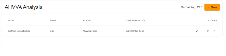
"STATUS - Analysis Failed"#
The “Analysis Failed” message appears when the AHVVA algorithm cannot find any paths to reach all the target sites because of issues with the AHVVA tools. This can happen if the marker is placed in an area the algorithm considers inaccessible by road or if there’s insufficient road data nearby. Placing an auto-path marker inside a building will result in an analysis failed error. We recommend to reperform the assessment, ensuring that the AHVVA tools used are positioned appropriately.
In the case of an analysis failure, the Assess Threat team is automatically notified and is currently investigating the issue. We will keep you informed and updated on our progress until the issue is resolved.
My Results Include Paths Which Cut Across Buildings#
When using the Auto-Path Marker, AHVVA relies on open-source data to detect whether buildings exist in the surrounding area and the boundaries of those buildings. Where there are buildings but no data indicating that the building is there, this may result in paths being returned that cut across buildings.
In this case, it is recommended that you re-perform the assessment with the Manual Path Tool or use the Blocking Element tool to manually designate the boundaries of the building.
Solution 1 (Recommended): Manually Block Out Surrounding Buildings and Re-Run the Assessment#
To ensure that paths do not cut through buildings, re-run the assessment and use the Blocking Element and manually trace the boundaries of the surrounding buildings around the target being assessed.
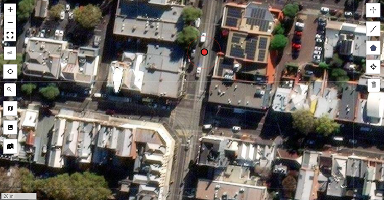
For example, the assessment below returned paths which crossed the surrounding buildings as boundary data about these buildings was not yet updated when the assessment was run:
To address this, the assessment was re-run after tracing the boundaries of the buildings around the target:
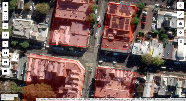
This will ensure that no paths will intersect or cut through these buildings when the analysis is run, even if up-to-date boundary information cannot be found.
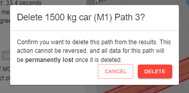
Solution 2: Manually Delete Paths That Cut Across Buildings#
Follow the instructions here to manually remove any paths that cut across buildings from your analysis results.
Issues with the Locate Me Tool#
On a PC, the Locate Me tool’s reliability can vary depending on several factors, including the location associated with where the IP address is registered. For AHVVA assessments, we recommend using the search bar to locate the area to be assessed.
Mapping Error#
When editing the map location, it may temporarily display a different area due to a known issue with the map services API. We recommend waiting for an hour before attempting again, as the API may resolve the issue on its own by then.
Please note that when editing an old assessment with a pin in a different location, the pin will remain in the old location until it is manually moved to the new site being assessed.
Contact us at hello@assessthreat.com and we will credit you back for the assessment that you just performed.